上海交通大学学报 ›› 2023, Vol. 57 ›› Issue (S1): 20-24.doi: 10.16183/j.cnki.jsjtu.2023.S1.15
周东荣1( ), 陈世海1, 蒋哲1, 严赛男1, 闫瑞海2, 高宇2
收稿日期:2022-07-07
修回日期:2022-07-25
接受日期:2022-08-22
出版日期:2023-10-27
发布日期:2023-11-10
作者简介:周东荣(1978-),教授级高级工程师,主要从事打捞及海洋工程研究. E-mail:
ZHOU Dongrong1(), CHEN Shihai1, JIANG Zhe1, YAN Sainan1, YAN Ruihai2, GAO Yu2
Received:2022-07-07
Revised:2022-07-25
Accepted:2022-08-22
Online:2023-10-27
Published:2023-11-10
摘要:
实景三维建模是数字经济和工程数字化建设的数字底座.介绍“长江口二号”古船整体迁移与保护项目中,利用无人机倾斜摄影技术进行影像采集和实景三维建模过程中关键技术和控制要点,并对实景三维模型建模中的空三测量精度进行分析,最后通过Web 3D GIS平台对实景三维模型进行可视化展示与应用探讨.
中图分类号:
周东荣, 陈世海, 蒋哲, 严赛男, 闫瑞海, 高宇. 无人机实景三维建模在“长江口二号”古船整体迁移与保护项目中的应用[J]. 上海交通大学学报, 2023, 57(S1): 20-24.
ZHOU Dongrong, CHEN Shihai, JIANG Zhe, YAN Sainan, YAN Ruihai, GAO Yu. Application of UAV Realistic 3D Modeling in Integral Relocation and Protection of “Yangtze River Estuary II” Ancient Ship[J]. Journal of Shanghai Jiao Tong University, 2023, 57(S1): 20-24.
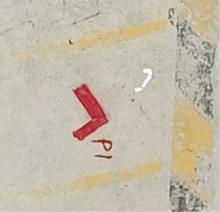
图1
像控点标志

表1
RTK卫星状态的基本要求
| 观测窗口状态 | 截止高度角15°以上的卫星个数 | PDOP值 |
|---|---|---|
| 良好 | >5 | <4 |
| 可用 | 5 | ≤6 |
| 不可用 | <5 | >6 |
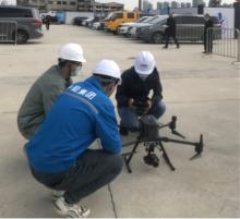
图2
飞机起飞前检查与参数设置

表2
控制点测量精度
| 点号 | 已校 准的 影像数 | 重投影 误差 RMS/ 像素 | 三维 误差/mm | 水平 误差/mm | 垂直 误差/mm | |
|---|---|---|---|---|---|---|
| P1 | 18 | 0.39 | 6.6 | X: 4.9 Y: 4.3 | 0.9 | |
| P2 | 19 | 0.57 | 2.9 | X: -2.7 Y: 0.8 | 0.5 | |
| P3 | 15 | 0.43 | 5.6 | X: -2.3 Y: -5 | 0.3 | |
| 整体RMS | 0.47 | 5.3 | X: 3.5 Y: 3.8 | 0.6 | ||
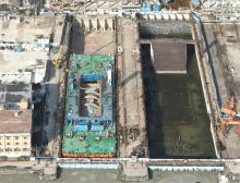
图3
实景三维模型

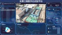
图4
“长江口二号”古船整体迁移与保护工程数字化平台

| [1] | 自然资源部办公厅. 自然资源部办公厅关于印发《实景三维中国建设技术大纲(2021版)》的通知[J]. 自然资源通讯, 2021(16): 21-24. |
| Office of the Ministry of Natural Resources. Notice of the general office of the ministry of natural resources on issuing the “real 3D china construction technology outline (2021 edition)”[J]. Natural resource communication, 2021(16): 21-24. | |
| [2] | 曹良中, 陈曦, 杨辽, 等. 基于倾斜影像的三维城市自动建模[J]. 测绘科学, 2017, 42(1): 124-130. |
| CAO Liangzhong, CHEN Xi, YANG Liao, et al. Automated three-dimensional urban modeling and accuracy evaluation using terabyte oblique aerial images[J]. Science of Surveying & Mapping, 2017, 42(1): 124-130. | |
| [3] | 严孝云. 基于倾斜摄影测量技术的实景三维建模技术研究[D]. 青岛: 山东科技大学, 2019. |
| YAN Xiaoyun. Real three-dimensional modeling technology based on oblique photogrammetry[D]. Qingdao: Shandong University of Science and Technology, 2019. | |
| [4] | 郑伯桢, 文政兵. 基于航摄技术的城市实景三维建模[J]. 测绘与空间地理信息, 2022, 45(5): 178-181. |
| ZHENG Bozhen, WEN Zhengbing. 3D modeling of city real scene based on aerial photography technology[J]. Geomatics & Spatial Information Technology, 2022, 45(5): 178-181. |
| [1] | 于佳琪1,王殊轶1,王浴屺1,谢华2,吴张檑1,付小妮1,马邦峰1. 基于增强现实技术的新型经皮肾穿刺训练可视化工具[J]. J Shanghai Jiaotong Univ Sci, 2023, 28(4): 517-. |
| [2] | 罗统, 张民, 梁承宇. 多无人机协同目标跟踪制导律设计[J]. 空天防御, 2023, 6(3): 113-118. |
| [3] | 黄鹤, 胡凯益, 李战一, 王会峰, 茹锋, 王珺. 融合MCAP和GRTV正则化的无人机航拍建筑物图像去雾方法[J]. 上海交通大学学报, 2023, 57(3): 366-378. |
| [4] | 黄鹤, 高永博, 茹锋, 杨澜, 王会峰. 基于自适应黏菌算法优化的无人机三维路径规划[J]. 上海交通大学学报, 2023, 57(10): 1282-1291. |
| [5] | 李登攀, 任晓明, 颜楠楠. 基于无人机航拍的绝缘子掉串实时检测研究[J]. 上海交通大学学报, 2022, 56(8): 994-1003. |
| [6] | 黄宇昊, 韩超, 赵明辉, 杜乾坤, 王石刚. 考虑安全飞行通道约束的无人机飞行轨迹多目标优化策略[J]. 上海交通大学学报, 2022, 56(8): 1024-1033. |
| [7] | 刘秀丽, 徐小力. 基于特征金字塔卷积循环神经网络的故障诊断方法[J]. 上海交通大学学报, 2022, 56(2): 182-190. |
| [8] | 聂瑞, 王红茹. 基于神经网络观测器的无人机编队执行器故障诊断[J]. 空天防御, 2022, 5(2): 32-41. |
| [9] | 罗菁, 张逸楠. 基于改进Grey-AHP的察打一体无人机作战效能评估方法[J]. 空天防御, 2022, 5(2): 1-7. |
| [10] | 周齐贤, 王寅, 孙学安. 基于增益自适应超螺旋滑模理论的无人机控制[J]. 上海交通大学学报, 2022, 56(11): 1453-1460. |
| [11] | 郭鹏军, 张睿, 高关根, 许斌. 基于相对速度和位置辅助的无人机编队协同导航[J]. 上海交通大学学报, 2022, 56(11): 1438-1446. |
| [12] | 李伟湋, 高培雪, 陈进, 路玉卿. 基于累积前景理论和三支决策的无人机态势评估[J]. 上海交通大学学报, 2022, 56(11): 1479-1490. |
| [13] | 王克帆, 邱潇颀, 高长生, 荆武兴. 临近空间太阳能无人机横航向变质心控制技术[J]. 空天防御, 2021, 4(4): 29-36. |
| [14] | 吴诗辉, 贾军, 鲍然, 周宇, 夏青元. 面向集群对抗的多弹协同目标分配模型与仿真分析[J]. 空天防御, 2021, 4(3): 1-9. |
| [15] | 姚天成, 赵永生, 王红雨, 何炎平, 丁子龙, 池哲瀛, 蔡炜锴. 风光混合驱动长航程无人海空立体探测船研发[J]. 上海交通大学学报, 2021, 55(2): 215-220. |
| 阅读次数 | ||||||
|
全文 |
|
|||||
|
摘要 |
|
|||||