上海交通大学学报 ›› 2023, Vol. 57 ›› Issue (3): 366-378.doi: 10.16183/j.cnki.jsjtu.2021.238
所属专题: 《上海交通大学学报》2023年“电子信息与电气工程”专题
• 电子信息与电气工程 • 上一篇
黄鹤a,b, 胡凯益a,b, 李战一a,b, 王会峰a,b, 茹锋a,b, 王珺a( )
)
收稿日期:2021-06-20
接受日期:2021-08-01
出版日期:2023-03-28
发布日期:2023-03-30
通讯作者:
王 珺,副教授,电话(Tel.): 029-88308121; E-mail:作者简介:黄 鹤(1979-),教授,主要从事信息融合,图像处理等方向研究.
基金资助:
HUANG Hea,b, HU Kaiyia,b, LI Zhanyia,b, WANG Huifenga,b, RU Fenga,b, WANG Juna()
Received:2021-06-20
Accepted:2021-08-01
Online:2023-03-28
Published:2023-03-30
摘要:
针对传统去雾处理复原得到的图像清晰度和对比度较低、整体颜色偏暗的问题,提出了一种改进的图像去雾方法,应用于无人机航拍建筑物图像处理中.针对全局大气光取值易受场景中景物影响的问题,提出一种颜色衰减先验投影最小方差的大气光求解方法,构建明度与饱和度差值图像,求解最小方差出现区域,并确定全局大气光估计.将利用图像场景深度信息求解的区域大气光与全局大气光相融合,获得新的大气光图.采用基于非局部信息的雾霾线先验理论对透射率进行优化,提出了一种基于雾霾线理论和引导相对总变分正则化的算法,通过计算透射率可靠性函数对透射率修正,并消除图像中存在的大量无用纹理信息,提升了透射率估计精度,有效改善了无人机航拍场景中浓雾及景深突变区域的复原图像质量.实验结果表明,所提算法与其他算法相比,获得的复原图像平均梯度、对比度、雾霾感知密度估计及模糊系数等指标分别平均提升了12.2%、7.0%、11.9%和12.5%,运算时长也优于部分算法,航拍图像更加清晰,更符合人眼视觉感受.
中图分类号:
黄鹤, 胡凯益, 李战一, 王会峰, 茹锋, 王珺. 融合MCAP和GRTV正则化的无人机航拍建筑物图像去雾方法[J]. 上海交通大学学报, 2023, 57(3): 366-378.
HUANG He, HU Kaiyi, LI Zhanyi, WANG Huifeng, RU Feng, WANG Jun. An Image Dehazing Method for UAV Aerial Photography of Buildings Combining MCAP and GRTV Regularization[J]. Journal of Shanghai Jiao Tong University, 2023, 57(3): 366-378.

图1
雾霾颗粒对成像的影响过程
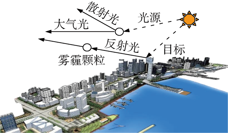

图2
CAP原理
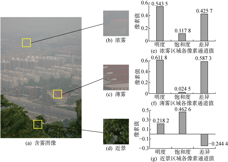

图3
含雾图像像素点在RGB颜色空间的分布
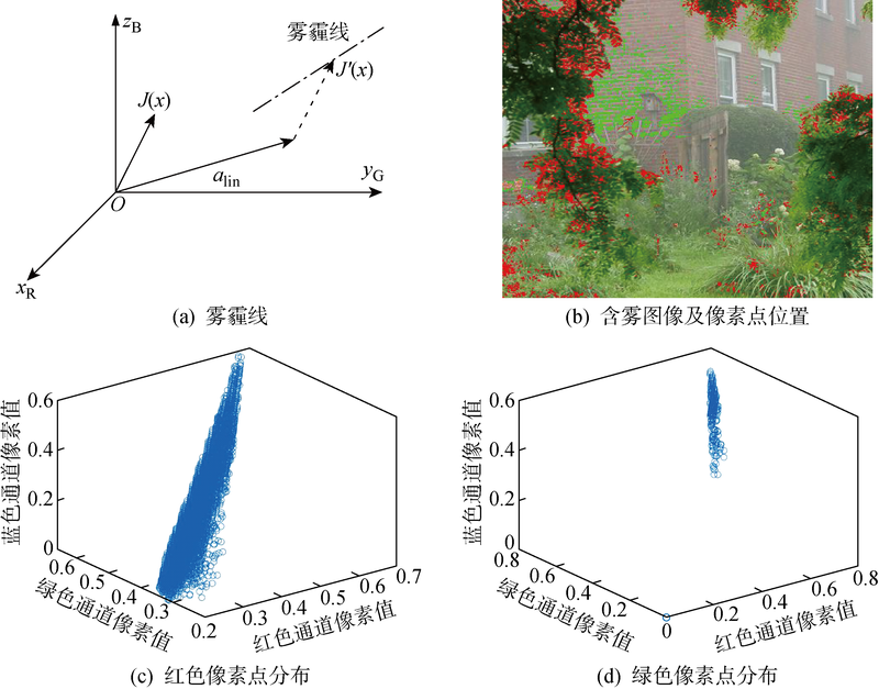
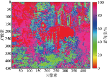
图4
透射率可靠性图
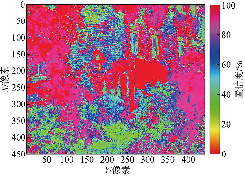

图5
算法流程
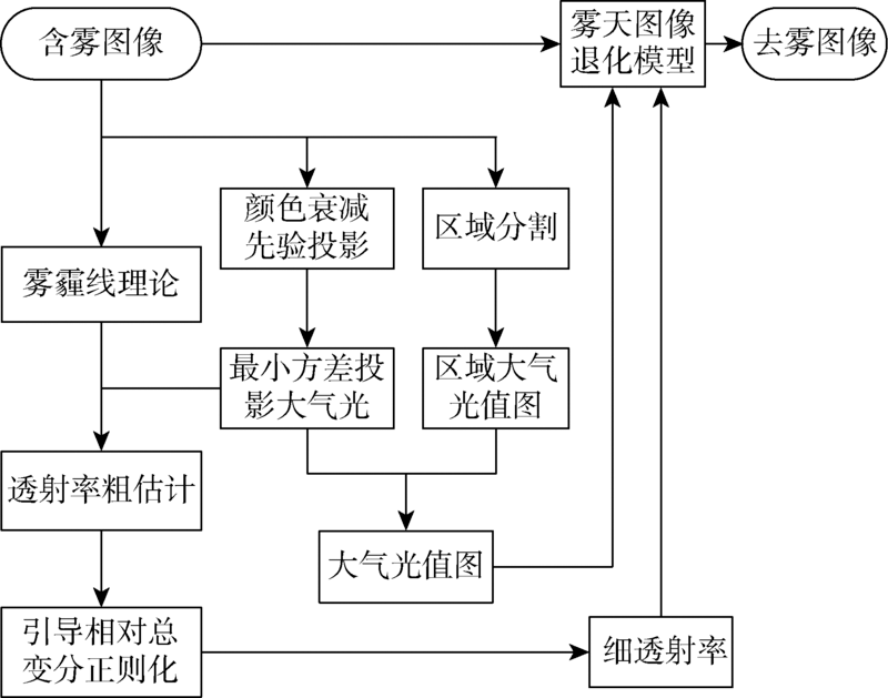
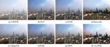
图6
E1图像去雾效果

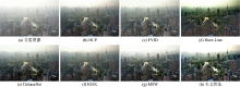
图7
E2图像去雾效果
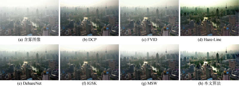
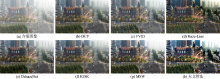
图8
E3图像去雾效果

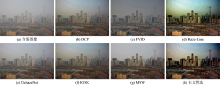
图9
E4图像去雾效果

表1
去雾图像参数评价
| 实验组 | 去雾算法 | 平均梯度 | 灰度图像对比度 | FADE | 模糊系数 | 运算时长/s |
|---|---|---|---|---|---|---|
| E1 | 原始图像 | 3.4132 | 38.0438 | 3.3746 | — | — |
| DCP[ | 4.6308 | 41.5066 | 1.6240 | 1.2875 | 10.83 | |
| FVID[ | 5.0402 | 44.8432 | 1.5107 | 1.3973 | 1.22 | |
| Haze-Line[ | 7.1235 | 66.1660 | 0.9111 | 1.9979 | 5.34 | |
| DehazeNet[ | 5.0708 | 55.1841 | 1.5434 | 1.3558 | 1.27 | |
| IGSK[ | 2.9055 | 43.6854 | 1.8265 | 0.4058 | 16.89 | |
| MSW[ | 5.4143 | 53.9913 | 1.4022 | 1.4407 | 2.54 | |
| 本文方法 | 8.1420 | 72.9530 | 0.7171 | 2.3017 | 6.21 | |
| E2 | 原始图像 | 2.7286 | 49.5167 | 2.3164 | — | — |
| DCP[ | 3.6947 | 56.4930 | 1.0717 | 1.3913 | 10.81 | |
| FVID[ | 4.4220 | 53.6060 | 1.2449 | 1.6863 | 0.81 | |
| Haze-Line[ | 4.9044 | 58.5268 | 0.5796 | 1.8093 | 4.07 | |
| DehazeNet[ | 4.1678 | 67.0087 | 0.7425 | 1.5658 | 1.27 | |
| IGSK[ | 2.0462 | 49.3389 | 2.9110 | 0.6316 | 16.40 | |
| MSW[ | 4.4642 | 71.8793 | 0.7974 | 1.6494 | 1.56 | |
| 本文方法 | 6.8819 | 72.3219 | 0.3560 | 2.5359 | 5.00 | |
| E3 | 原始图像 | 4.0277 | 34.3381 | 1.4294 | — | — |
| DCP[ | 6.2019 | 37.0552 | 0.5512 | 1.5606 | 10.78 | |
| FVID[ | 6.5895 | 36.3347 | 0.5775 | 1.7264 | 0.81 | |
| Haze-Line[ | 8.5561 | 34.4546 | 0.2612 | 2.1607 | 4.68 | |
| DehazeNet[ | 6.4785 | 44.1485 | 0.4464 | 1.6495 | 1.25 | |
| IGSK[ | 3.0247 | 33.7982 | 1.8486 | 0.6427 | 16.47 | |
| MSW[ | 7.3224 | 50.1062 | 0.4932 | 1.8492 | 1.54 | |
| 本文方法 | 11.6165 | 57.2106 | 0.1953 | 2.9986 | 5.01 | |
| E4 | 原始图像 | 3.6964 | 28.8263 | 2.2842 | — | — |
| DCP[ | 5.1626 | 35.8074 | 1.1885 | 1.6117 | 10.89 | |
| FVID[ | 5.7754 | 19.5894 | 1.2384 | 1.7113 | 0.81 | |
| Haze-Line[ | 9.7989 | 57.8329 | 0.4250 | 2.5171 | 4.34 | |
| DehazeNet[ | 5.3420 | 38.9765 | 1.3434 | 1.6479 | 1.31 | |
| IGSK[ | 1.8620 | 28.6709 | 3.4998 | 0.2421 | 16.58 | |
| MSW[ | 6.2033 | 48.6046 | 1.0322 | 1.7546 | 1.53 | |
| 本文方法 | 9.6690 | 59.4137 | 0.2788 | 2.5483 | 4.72 |
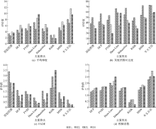
图10
去雾图像参数评价

| [1] |
KIM J Y, KIM L S, HWANG S H. An advanced contrast enhancement using partially overlapped sub-block histogram equalization[J]. IEEE Transactions on Circuits and Systems for Video Technology, 2001, 11(4): 475-484.
doi: 10.1109/76.915354 URL |
| [2] |
OAKLEY J P, SATHERLEY B L. Improving image quality in poor visibility conditions using a physical model for contrast degradation[J]. IEEE Transactions on Image Processing, 1998, 7(2): 167-179.
doi: 10.1109/83.660994 pmid: 18267391 |
| [3] | TAN K, OAKLEY J P. Enhancement of color images in poor visibility conditions[C]// Proceedings 2000 International Conference on Image Processing. Vancouver, BC, Canada: IEEE, 2000: 788-791. |
| [4] |
NARASIMHAN S G, NAYAR S K. Contrast restoration of weather degraded images[J]. IEEE Transactions on Pattern Analysis and Machine Intelligence, 2003, 25(6): 713-724.
doi: 10.1109/TPAMI.2003.1201821 URL |
| [5] |
HE K M, SUN J, TANG X O. Single image haze removal using dark channel prior[J]. IEEE Transactions on Pattern Analysis and Machine Intelligence, 2011, 33(12): 2341-2353.
doi: 10.1109/TPAMI.2010.168 pmid: 20820075 |
| [6] |
ZHU Q S, MAI J M, SHAO L. A fast single image haze removal algorithm using color attenuation prior[J]. IEEE Transactions on Image Processing, 2015, 24(11): 3522-3533.
doi: 10.1109/TIP.2015.2446191 pmid: 26099141 |
| [7] |
CAI B L, XU X M, JIA K, et al. DehazeNet: An end-to-end system for single image haze removal[J]. IEEE Transactions on Image Processing, 2016, 25(11): 5187-5198.
doi: 10.1109/TIP.2016.2598681 pmid: 28873058 |
| [8] | BERMAN D, TREIBITZ T, AVIDAN S. Non-local image dehazing[C]// 2016 IEEE Conference on Computer Vision and Pattern Recognition. Las Vegas, NV, USA: IEEE, 2016: 1674-1682. |
| [9] |
BERMAN D, TREIBITZ T, AVIDAN S. Single image dehazing using haze-lines[J]. IEEE Transactions on Pattern Analysis and Machine Intelligence, 2020, 42(3): 720-734.
doi: 10.1109/TPAMI.2018.2882478 pmid: 30475710 |
| [10] | XU L, YAN Q, XIA Y, et al. Structure extraction from texture via relative total variation[J]. ACM Transactions on Graphics, 2012, 31(6): 1-10. |
| [11] |
CHOI L K, YOU J, BOVIK A C. Referenceless prediction of perceptual fog density and perceptual image defogging[J]. IEEE Transactions on Image Processing, 2015, 24(11): 3888-3901.
doi: 10.1109/TIP.2015.2456502 pmid: 26186784 |
| [12] |
HUANG H, SONG J, GUO L, et al. Haze removal method based on a variation function and colour attenuation prior for UAV remote-sensing images[J]. Journal of Modern Optics, 2019, 66(12): 1282-1295.
doi: 10.1080/09500340.2019.1615141 URL |
| [13] | GALDRAN A, VAZQUEZ-CORRAL J, PARDO D, et al. Fusion-based variational image dehazing[J]. IEEE Signal Processing Letters, 2017, 24(2): 151-155. |
| [14] | 汪贵平, 宋京, 杜晶晶, 等. 基于改进梯度相似度核的交通图像去雾算法[J]. 中国公路学报, 2018, 31(6): 264-271. |
| WANG Guiping, SONG Jing, DU Jingjing, et al. Haze defogging algorithm for traffic images based on improved gradient similarity kernel[J]. China Journal of Highway and Transport, 2018, 31(6): 264-271. | |
| [15] | 黄鹤, 李昕芮, 宋京, 等. 多尺度窗口的自适应透射率修复交通图像去雾方法[J]. 中国光学, 2019, 12(6): 1311-1320. |
|
HUANG He, LI Xinrui, SONG Jing, et al. A traffic image dehaze method based on adaptive transmittance estimation with multi-scale window[J]. Chinese Optics, 2019, 12(6): 1311-1320.
doi: 10.3788/co. URL |
|
| [16] | 董亚运, 毕笃彦, 何林远, 等. 基于非局部先验的单幅图像去雾算法[J]. 光学学报, 2017, 37(11): 83-93. |
| DONG Yayun, BI Duyan, HE Linyuan, et al. Single image dehazing algorithm based on non-local prior[J]. Acta Optica Sinica, 2017, 37(11): 83-93. | |
| [17] | 黄鹤, 胡凯益, 宋京, 等. 雾霾线求解透射率的二次优化方法[J]. 西安交通大学学报, 2021, 55(8): 130-138. |
| HUANG He, HU Kaiyi, SONG Jing, et al. A twice optimization method for solving transmittance with haze-lines[J]. Journal of Xi’an Jiaotong University, 2021, 55(8): 130-138. |
| [1] | 顾闻,徐奕. 基于对抗学习和迭代优化的视网膜血管分割[J]. J Shanghai Jiaotong Univ Sci, 2024, 29(1): 73-80. |
| [2] | 周东荣, 陈世海, 蒋哲, 严赛男, 闫瑞海, 高宇. 无人机实景三维建模在“长江口二号”古船整体迁移与保护项目中的应用[J]. 上海交通大学学报, 2023, 57(S1): 20-24. |
| [3] | 张泽龙, 张颖超, 伍波, 董威, 樊友本. 高灰度级高分辨率激光散斑血流实时成像研究[J]. 上海交通大学学报, 2023, 57(5): 552-559. |
| [4] | 罗统, 张民, 梁承宇. 多无人机协同目标跟踪制导律设计[J]. 空天防御, 2023, 6(3): 113-118. |
| [5] | 黄鹤, 高永博, 茹锋, 杨澜, 王会峰. 基于自适应黏菌算法优化的无人机三维路径规划[J]. 上海交通大学学报, 2023, 57(10): 1282-1291. |
| [6] | 黄宇昊, 韩超, 赵明辉, 杜乾坤, 王石刚. 考虑安全飞行通道约束的无人机飞行轨迹多目标优化策略[J]. 上海交通大学学报, 2022, 56(8): 1024-1033. |
| [7] | 李登攀, 任晓明, 颜楠楠. 基于无人机航拍的绝缘子掉串实时检测研究[J]. 上海交通大学学报, 2022, 56(8): 994-1003. |
| [8] | 孙棪伊, 范文晶, 曾远帆, 干兴业, 汤日佳, 韩锐. 基于Harris角点检测的装填靶标识别方法[J]. 空天防御, 2022, 5(4): 87-91. |
| [9] | 聂瑞, 王红茹. 基于神经网络观测器的无人机编队执行器故障诊断[J]. 空天防御, 2022, 5(2): 32-41. |
| [10] | 罗菁, 张逸楠. 基于改进Grey-AHP的察打一体无人机作战效能评估方法[J]. 空天防御, 2022, 5(2): 1-7. |
| [11] | 周齐贤, 王寅, 孙学安. 基于增益自适应超螺旋滑模理论的无人机控制[J]. 上海交通大学学报, 2022, 56(11): 1453-1460. |
| [12] | 郭鹏军, 张睿, 高关根, 许斌. 基于相对速度和位置辅助的无人机编队协同导航[J]. 上海交通大学学报, 2022, 56(11): 1438-1446. |
| [13] | 李伟湋, 高培雪, 陈进, 路玉卿. 基于累积前景理论和三支决策的无人机态势评估[J]. 上海交通大学学报, 2022, 56(11): 1479-1490. |
| [14] | 王克帆, 邱潇颀, 高长生, 荆武兴. 临近空间太阳能无人机横航向变质心控制技术[J]. 空天防御, 2021, 4(4): 29-36. |
| [15] | 吴诗辉, 贾军, 鲍然, 周宇, 夏青元. 面向集群对抗的多弹协同目标分配模型与仿真分析[J]. 空天防御, 2021, 4(3): 1-9. |
| 阅读次数 | ||||||
|
全文 |
|
|||||
|
摘要 |
|
|||||